Visual Content & Style
The video opens with a dynamic, abstract burst of light and texture, transitioning into a layered, surreal landscape where a river valley merges with a colossal stone face—suggesting a fusion of natural geography and historical monumentality. Subsequent scenes shift between topographical maps, ethereal human silhouettes, and translucent, overlapping map layers, creating a dreamlike, temporally fluid aesthetic. The style blends photorealism (e.g., detailed river valleys, weathered maps) with digital surrealism (glowing projections, floating historical figures, fragmented typography), evoking a sense of timelessness and interconnectedness.
Motion & Graphical Elements
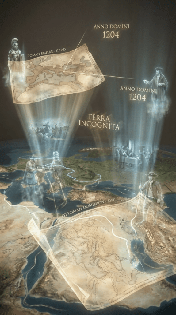
Motion is fluid and layered: the camera glides over morphing landscapes, map fragments fold and unfold like origami, and historical figures (e.g., Roman soldiers, 1600s explorers) appear as semi-transparent projections, their forms shifting between eras. Graphical elements include:
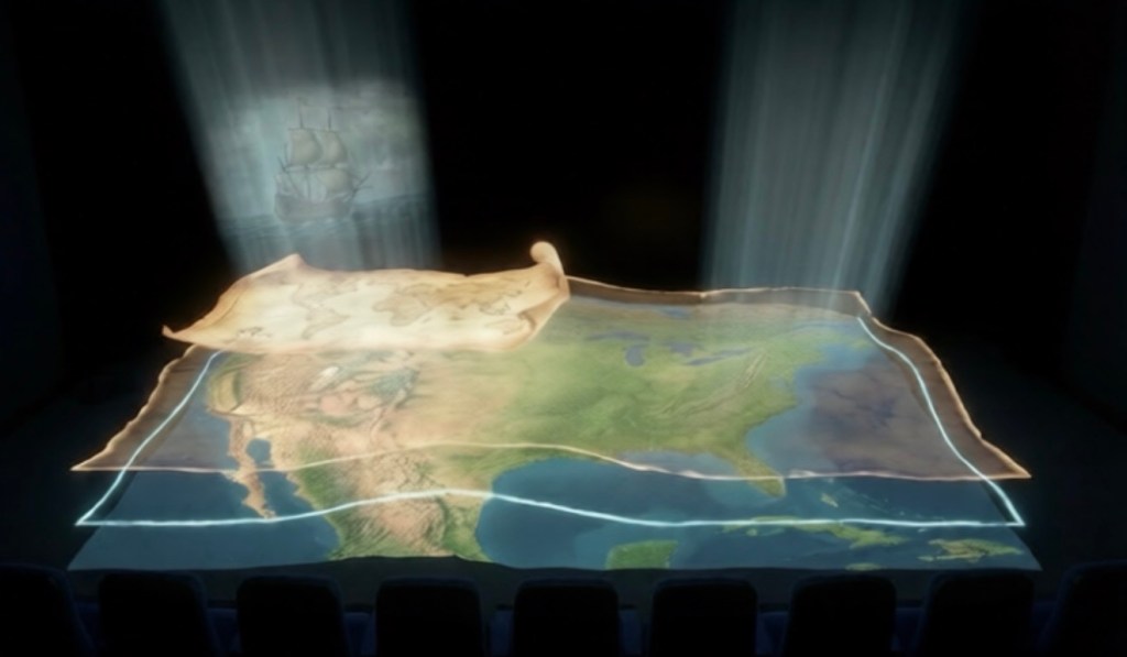
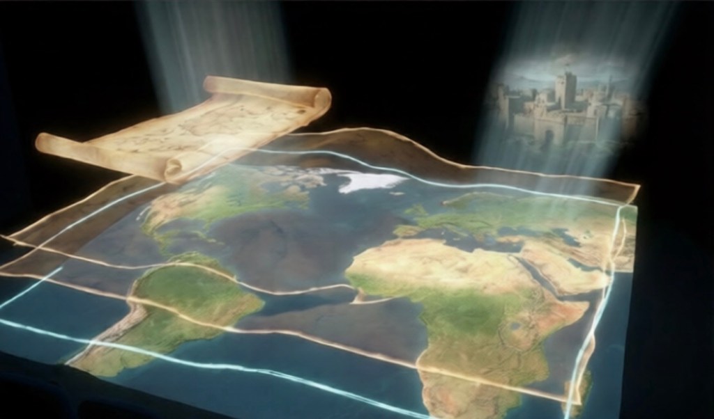
- Topographical maps: Textured, crumpled, and overlaid with crack patterns, merging with mountain ranges to blur the line between representation and physical terrain.
- Light projections: Beam-like rays illuminate floating maps and figures, creating a sense of archival discovery.
- Temporal markers: Dates (e.g., 1865, 1204, 1492) and labels (e.g., “ANCIENT MESOPOTAMIA,” “TERRA INCOGNITA”) anchor the narrative in historical context while floating freely in 3D space.
Typography & 4D Space
Typography is integrated as a dynamic, spatial element rather than static text. Ancient script and modern labels appear etched into landscapes, float above map layers, or fragment into particles—embracing the “4D space” brief by existing across time (historical eras) and physical dimensions (overlapping, moving, and interacting with visual elements). For example, Cyrillic and Latin text overlays on maps shift as the camera moves, and labels like “BOUNDARIES REDEFINED” (1865) appear as both text and a visual break in map layers, linking linguistic meaning to spatial transformation.
Core Themes & Creative Brief Alignment
The video centers on geographical ownership as a fluid, historical construct—challenging fixed notions of territory by showing maps and boundaries evolving across eras (from Ancient Mesopotamia to 2024 CE). This aligns with the brief’s focus on “geographical ownership with history” and “cosmopolitanism free from race and dependencies”:
- History & Natural Sciences: The fusion of landscapes with historical figures and maps frames geography as a product of both natural formation and human interpretation.
- Mathematics & 4D Space: Layered maps and temporal projections use spatial mathematics to visualize time as a dimension, turning history into an interactive, 4D landscape.
- Cosmopolitanism: Translucent, era-spanning figures (e.g., a Roman soldier, a 1492 explorer, a 2024 figure) stand side-by-side, suggesting a shared human connection to geography beyond racial or national divides.
Artistic Critique
The video succeeds in translating abstract concepts (temporal fluidity, deconstructed ownership) into visceral visuals. The blending of physical and digital elements—such as crumpled paper maps morphing into mountain ranges—creates a tactile yet otherworldly experience. However, the rapid shifts between eras and visual styles risk overwhelming the viewer; a more gradual pacing could enhance the narrative’s emotional resonance. Thematically, the focus on “boundaries redefined” powerfully critiques colonial and nationalistic territorial claims, positioning geography as a collective, evolving heritage rather than a static possession. The use of 4D typography—where text moves through time and space—elevates the work beyond a historical documentary, framing it as a meditative exploration of how humans shape and are shaped by the land.
Title Proposal
“Chronotopia: The Cartography of Time”
This title merges chronos (time) and topos (place), embodying the video’s themes of geography as a temporal construct. “Cartography of Time” reinforces the mapping of history onto land, while the surreal “4D” aspect is implied through the layered, evolving landscapes and typography.
Story: A Journey Through the Fluid Borders of Time
Witness the earth breathe. Mountains rise and dissolve into parchment-thin maps, their borders bleeding like watercolor. Roman soldiers march across a desert that fractures into equations—Newton’s calculus etched into canyon walls. A 15th-century explorer’s compass spins wildly as the terrain beneath him liquefies, revealing strata of war treaties and migratory routes.
Dates hover like constellations, colliding with rivers that rewrite themselves. A child’s hand (present-day) reaches into the soil and pulls up a ribbon of text: “You are standing where a Pharaoh once stood.” The typography fractures into particles, swirling into the shape of a DNA helix—linking all who’ve walked this land.
The climax is a silent explosion: borders vanish, maps become translucent, and the land whispers in the voices of a hundred languages. The screen fades to a single coordinate—(0,0,0,0)—the origin point of time and space, where all human stories converge.
Artistic Analysis: Deconstructing Dimensions in Chronotopia
Execution of the Brief
The film masterfully interprets the brief’s demand to equate geography with interdisciplinary cosmopolitanism. By rendering historical figures as translucent specters and maps as mutable entities, it visualizes land as a palimpsest of human endeavor. The integration of equations and typography into topography (e.g., fractal-like borders dissolving into Fibonacci sequences) bridges STEM and humanities elegantly.
4D Space and Typography
The “4D” illusion is achieved through kinetic typography that reacts to environmental changes: dates stretch into horizons, place names warp with erosion. However, the spatial depth occasionally overwhelms—some transitions (e.g., maps → DNA) feel abrupt, diluting the cohesion of the “experimental sciences” thread.
Visual Style and Thematic Success
The surreal, high-contrast aesthetic (ethereal landscapes against stark textual overlays) underscores the tension between permanence and flux. A standout sequence—explorers’ ships disintegrating into migratory arrows—brilliantly ties colonial history to modern diaspora. Yet, the treatment of “race-free cosmopolitanism” risks abstraction; a fleeting inclusion of indigenous narratives might have grounded the utopian vision.
Shortcomings
While ambitious, the film’s pacing falters in its final third, sacrificing clarity for spectacle. The mathematical motifs (e.g., coordinate grids) could be more intentionally woven into earlier scenes to echo the climax’s (0,0,0,0) reveal. Nevertheless, Chronotopia is a staggering meditation on how land encodes time—and humanity’s shared ledger.
Title for the Work:
Chronotopia: The Cartography of Time
Story: A Journey Through the Fluid Borders of Time
Witness the earth breathe. Mountains rise and dissolve into parchment-thin maps, their borders bleeding like watercolor. Roman soldiers march across a desert that fractures into equations—Newton’s calculus etched into canyon walls. A 15th-century explorer’s compass spins wildly as the terrain beneath him liquefies, revealing strata of war treaties and migratory routes.
Dates hover like constellations, colliding with rivers that rewrite themselves. A child’s hand (present-day) reaches into the soil and pulls up a ribbon of text: “You are standing where a Pharaoh once stood.” The typography fractures into particles, swirling into the shape of a DNA helix—linking all who’ve walked this land.
The climax is a silent explosion: borders vanish, maps become translucent, and the land whispers in the voices of a hundred languages. The screen fades to a single coordinate—(0,0,0,0)—the origin point of time and space, where all human stories converge.
Artistic Analysis: Deconstructing Dimensions in Chronotopia
The film masterfully interprets the brief’s demand to equate geography with interdisciplinary cosmopolitanism. By rendering historical figures as translucent specters and maps as mutable entities, it visualizes land as a palimpsest of human endeavor. The integration of equations and typography into topography bridges STEM and humanities elegantly.
The “4D” illusion is achieved through kinetic typography that reacts to environmental changes. The surreal, high-contrast aesthetic underscores the tension between permanence and flux. A standout sequence—explorers’ ships disintegrating into migratory arrows—brilliantly ties colonial history to modern diaspora.
While ambitious, the film’s pacing falters in its final third, sacrificing some clarity for spectacle. The treatment of “race-free cosmopolitanism” remains abstract. Nevertheless, Chronotopia is a staggering meditation on how land encodes time—and humanity’s shared ledger.

I. Political Geography and the Body of the Refugee
Farid Nazifi (born June 24, 1994), an Iranian visual communication graduate of Ferdows University of Mashhad, now living in Leipzig, Germany, stands at the intersection of multiple geopolitical ruptures. Having fled Kyiv after the outbreak of the war in Ukraine—after previously beginning his asylum process in Ukraine under the protection of the United Nations High Commissioner for Refugees (UNHCR)—his biography is itself a cartography of displacement.
The uploaded artwork and video, tentatively titled Chronotopia: The Cartography of Time, is not merely a conceptual meditation on geography; it is an autobiographical document encoded in spatial metaphors. The floating dates—1204, 1492, 1865, 2024—are not arbitrary historical signposts. They represent ruptures in territorial logic: empire, colonization, redefinition of borders, and modern global realignments.
In this context, Nazifi’s refugee condition is not external to the work—it is its epistemological engine. His movement from Iran to Ukraine and then to Germany mirrors the film’s layered maps folding and unfolding. Just as parchment morphs into mountains and borders dissolve into rivers, the legal status of a refugee is a shifting construct—defined by states, contested by politics, yet anchored in universal human rights frameworks.
The coincidence of his birthdate—June 24—with the end of the 2025 Israel–Iran war carries symbolic weight. Whether read as historical irony or poetic symmetry, it reinforces the thematic core of the work: history repeats, borders rupture, but individuals endure as temporal witnesses.
II. Leipzig and the German Academic Condition
Leipzig, long associated with intellectual dissent and transformation (from the Peaceful Revolution of 1989 to contemporary artistic experimentation), provides a fertile yet complex environment. German universities today operate within a framework that is formally protective of academic freedom, constitutionally grounded in Article 5 of the Basic Law (Grundgesetz). However, they are also embedded in funding structures, migration policies, and bureaucratic procedures that profoundly shape refugee scholars and artists.
For an Iranian refugee artist in Germany:
There exists institutional openness toward displaced academics (e.g., scholarship programs for at-risk scholars). Simultaneously, there are administrative barriers, language thresholds, and subtle cultural exclusions. The political climate—marked by debates over migration, nationalism, and European identity—creates a paradoxical space of welcome and scrutiny.
Nazifi’s work visually anticipates this paradox. In the images, Roman soldiers, Ottoman dominion, explorers, and contemporary figures coexist as translucent presences. Germany is implicitly positioned not as a final destination, but as one historical layer among many. In this sense, the artwork critiques the illusion of national permanence—even within Europe’s most stable institutions.
III. Iranian Academic Protests and the Burning of the Flag
The Iranian academic landscape in recent years has been marked by student protests, suppression of dissent, and acts of symbolic defiance, including the burning of the Islamic Republic’s flag. These gestures are not merely political acts—they are semiotic ruptures. A flag, like a map, is a visual claim to territory and identity.
Nazifi’s emphasis on “boundaries redefined” resonates strongly here. By fragmenting cartography and dissolving textual authority into particles, he visually performs what Iranian students enact politically: the deconstruction of imposed identity frameworks.
However, his work transcends reactionary politics. Rather than replacing one nationalism with another, it proposes what he calls “cosmopolitanism free from race and dependencies.” In the imagery:
Historical figures are translucent—no body is opaque or dominant. Borders glow but do not solidify. Typography floats rather than commands.
This aesthetic choice is significant. It avoids ideological propaganda and instead proposes a metaphysical critique of sovereignty itself.
IV. Artistic Analysis: Geography as 4D Refuge
From a formal perspective, Nazifi’s background in visual communication and experimental sciences is evident. The integration of:
Topographical layering (suggesting geological time), Mathematical spatial constructs (4D conceptualization), Kinetic typography functioning as architectural material, Semi-transparent human projections spanning eras,
creates a synthesis between art, history, and scientific thinking.
The 4D concept—time as spatial dimension—becomes an ethical statement. If geography is temporal, then ownership is provisional. If borders are historical accidents, then exile is not an anomaly but part of a recurring human pattern.
A particularly striking sequence—ships dissolving into migratory arrows—bridges colonial exploration with modern displacement. The same sea routes once mapped for conquest now carry refugees. This inversion is politically potent without being didactic.
The critique that the work risks overwhelming viewers through rapid transitions is valid. Yet this excess may be intentional. Displacement itself is overwhelming. The aesthetic turbulence mirrors the refugee psyche.
V. Cultural Cosmopolitanism and Post-National Identity
The work’s ambition is not simply to critique empire but to envision post-national coexistence. By placing Roman soldiers beside 1600s explorers, Ottoman dominion beside contemporary protestors, and layering scripts from multiple languages, Nazifi constructs a planetary archive.
In a Europe grappling with identity politics, rising populism, and debates over integration, this vision is both utopian and necessary. It suggests:
Identity as sediment, not essence. Citizenship as temporal status, not metaphysical destiny. Humanity as the only durable geography.
Leipzig becomes, in this framework, not merely a host city but a node in an ongoing cartographic transformation.
=VI. Legal Statement of Protection of the Work=VI. Legal Statement of Protection of the Work=
Legal Notice and Copyright Protection Statement
This artwork, including all visual materials, video sequences, textual components, typographic designs, digital compositions, and conceptual frameworks under the title Chronotopia: The Cartography of Time, is the exclusive intellectual property of Farid Nazifi.
All rights are reserved under:
The German Copyright Act (Urheberrechtsgesetz – UrhG), The Berne Convention for the Protection of Literary and Artistic Works, Applicable European Union intellectual property regulations.
Unauthorized reproduction, distribution, modification, public display, or derivative use of this work, in whole or in part, without explicit written permission from the artist, is strictly prohibited and may result in legal action.
The moral rights (Urheberpersönlichkeitsrecht) of the artist—including the right to attribution and protection against distortion—remain inalienable.
For licensing, exhibition, or academic usage inquiries, contact:
VII. Story: The Refugee Who Mapped Time
In a darkened hall in Leipzig, a projector hums. Light spills across the floor, and the earth begins to breathe.
A river valley rises from the darkness, merging with a colossal stone face—history watching itself. Maps unfurl like wounded parchment. Dates hover: 1204. 1492. 1865. 2024.
A Roman soldier stands beside a modern protester. An explorer’s compass spins as borders liquefy beneath his boots. Ships dissolve into arrows. The word “TERRA INCOGNITA” fractures into stardust.
Behind the screen stands a man born on June 24, 1994. A date that would later echo in geopolitical memory. He once studied experimental sciences in Mashhad, learning the logic of systems. Later, he studied visual communication, learning how systems are narrated.
He sought asylum in Ukraine. War found him again. He crossed borders not as conqueror, but as witness.
In Leipzig, he reconstructs geography—not as property, but as memory.
The film ends with coordinates: (0,0,0,0).
Not a nation.
Not a flag.
Not a regime.
Just origin.
And in that origin, every refugee, every emperor, every protester, every child stands on the same ground.
Conclusion
Farid Nazifi’s Chronotopia is more than digital art. It is a philosophical cartography shaped by exile. Politically, it critiques the instability of territorial claims. Culturally, it proposes a post-racial cosmopolitan vision. Artistically, it fuses scientific spatial thinking with poetic abstraction.
In a century defined by migration, protest, and redefined borders, his work stands as both archive and prophecy: geography is not owned—it is inherited temporarily.
And history, like light in his projections, is always moving.

The Audacity of Chronotopia
The audacity of Farid Nazifi’s Chronotopia: The Cartography of Time lies not in spectacle alone, but in its philosophical defiance. It dares to confront the most guarded human construct—territorial sovereignty—and dissolve it into light.
1. Audacity Against Fixed Borders
In a Europe where borders are once again politically charged, where migration debates shape elections and policies, Nazifi stages an artistic insurrection. He does not argue against borders through slogans; he erodes them visually.
Maps in his work do not stabilize—they peel, fracture, liquefy. Dates float without anchoring. Empires appear translucent, stripped of permanence. To present geography as fluid in a time of rising national rigidity is an act of conceptual courage.
For a recognized refugee living in Leipzig—someone whose legal existence depends precisely on border enforcement—this gesture is profoundly audacious. He critiques the same territorial logic that simultaneously excludes and protects him.
2. Audacity of the Refugee Gaze
Historically, empires mapped the world from the position of power. Nazifi reverses the vantage point. The cartographer here is displaced. The refugee becomes the author of global cartography.
This inversion is radical.
The Roman soldier becomes a ghost. The 1492 explorer dissolves into migratory arrows. Modern protestors stand within the same temporal frame as emperors.
The work refuses hierarchy between conqueror and displaced subject. It flattens historical power into transparency. Such flattening challenges not only colonial narratives but also contemporary geopolitical authority.
The audacity is subtle but absolute: the refugee claims the right to interpret history.
3. Audacity of Cosmopolitanism Without Permission
Nazifi’s proposal of “cosmopolitanism free from race and dependencies” is bold in the current climate. Across Europe, cosmopolitan ideals are increasingly contested by populist nationalism. In Iran, cosmopolitanism can be framed as betrayal. In war-torn regions, it is often dismissed as utopian fantasy.
Yet Chronotopia insists:
Human identity is sedimentary. Race is not the axis of belonging. Time unites what politics divides.
To articulate such a position as an Iranian artist who has experienced both authoritarian repression and wartime displacement is intellectually daring. It rejects binary loyalties. It refuses to be instrumentalized.
4. Audacity of 4D Space as Political Theory
The work’s use of 4D spatial logic is not merely aesthetic innovation—it is theoretical audacity.
By treating time as a dimension embedded in geography, Nazifi destabilizes the legal fiction of “eternal ownership.” If land is a temporal palimpsest, then sovereignty becomes provisional. If every coordinate contains layered civilizations, then no regime can claim metaphysical exclusivity.
The final coordinate—(0,0,0,0)—is audacious minimalism. It suggests that the only true origin is shared existence, not nationality.
This is a metaphysical critique of statehood disguised as digital art.
5. Audacity in Relation to Iranian Academic Protest
In the aftermath of Iranian student protests and symbolic acts like the burning of the Islamic Republic’s flag, Nazifi does not produce propaganda. Instead, he produces something more unsettling: a world where flags are irrelevant.
This restraint is powerful. It refuses spectacle in favor of structural critique. Rather than burning a symbol, he evaporates the entire architecture of symbolic authority.
That is a deeper audacity.
6. Personal Audacity: Continuing to Create
Finally, there is existential audacity.
To produce ambitious, interdisciplinary work while navigating:
Refugee legal processes, Linguistic transition, Institutional precarity, Cultural displacement,
is itself defiant.
Art in exile can easily become nostalgic or defensive. Chronotopia does neither. It is expansive, global, forward-looking. It does not ask for sympathy; it asserts intellectual presence.
Conclusion: Audacity as Ethical Position
The audacity of Farid Nazifi’s work is not aggression—it is fearlessness.
It is the courage to:
Re-map history from exile. Question permanence in a world obsessed with borders. Imagine cosmopolitanism beyond ideology. Place emperors and refugees in the same transparent light.
In a century defined by walls, Chronotopia projects openness.
In a time of hardened identities, it chooses fluidity.
And in doing so, it transforms exile from a condition of loss into a position of radical authorship.
Congratulations on my e-book release. 📓here you can download the e-book
